We have taken the Monkrigg example, collected by David Sowerby as it illustrates what we are trying to do, to shoehorn data from different researchers – who have approached the problem differently – into a single but simple template. David’s example illustrates the difficulties of incorporating diachronic data (from 2 or more different periods), so was useful to work through.
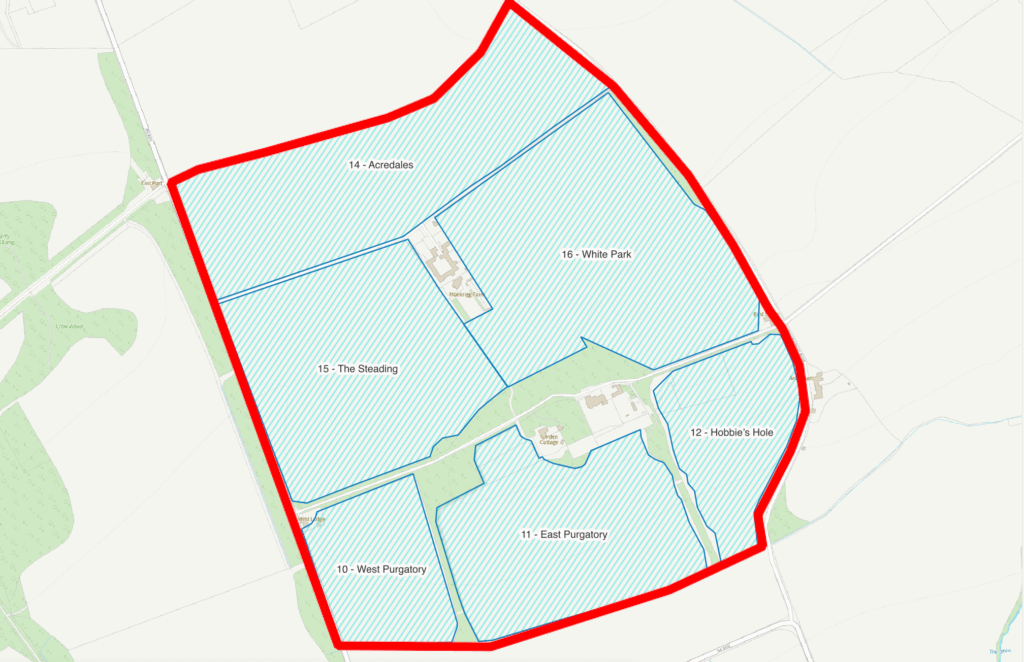
Above is the original report, which turns into something like this (worked example in QGIS):
This is what we want to end up with, I think is something like this:
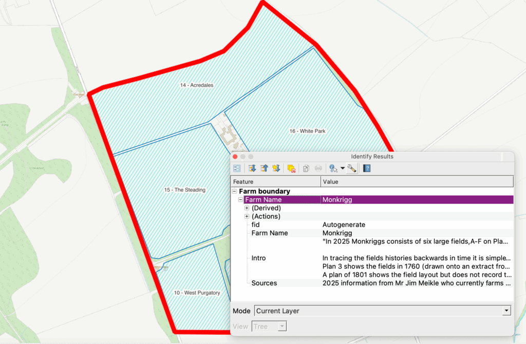
At this stage we had concluded the farm boundary probably needs to be another layer and any introductory blurb and perhaps the sources would be entered only in the first numbered field:
And the info popup something like
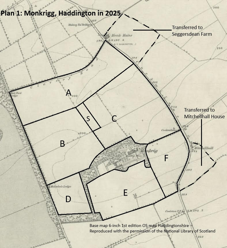
In practice the current farm boundary can be a complex multipolygon, with holes (e.f. where housing development or a sale of a steading has occurred). We therefore ended up simply labelling which farm they belong to, which in practice may involve 1 owner with multiple holdings.
The approach means that the field or plot is the main entity recorded, rather than the cadastral boundary, which raises further difficulties when the area farmed may simply be rented.
Original Table
| Field No. | Grid Ref | Field Name | Name derivation, any known previous names, sources details and other observations |
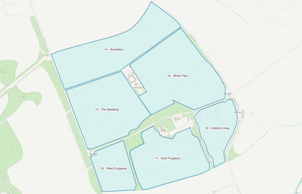
| A | NT52376/72763 | Acredales | Field A was created by combining fields 1 and 2, the name of field 2 remaining in use for the combined field. |
| B | NT52318/72434 | The Steading | Field B has clearly been named for its proximity to the actual Steading buildings. It combines two fields, Middle Park (4) and West Lodge Park (7), neither name surviving. This new name must have been decided upon at the same time as or after Field C was created as it incorporated Field 5 which was also called Steading Park. |
| C | NT52665/72628 | White Park | Field C was formed from four fields: 5,6,8 & 9. Its name is a shortened form of the name of Field 6, White Dykes Park. |
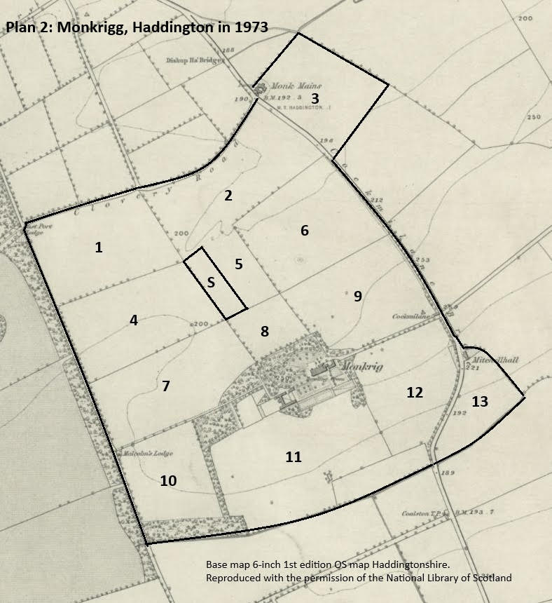
| 1 | NT52161/72697 | Shinnems Hedge | This field is present on the 1854 6-inch OS map and the 1801 plan. The 1760 plan shows it divided into a series of strips or dales and is named as Skinners Edge (no H). So the (h)edge element of the older name has survived while Skinners has been corrupted verbally or misinterpreted when rewritten with perhaps the ‘k’ being read as an ‘h’ (a Secretary Hand k having a similar form to a modern hand h) and the ‘r’ being read as ‘n/m’. So probably named for a person or occupation. |
| 2 | NT52496/72833 | Acredales | This name combines two words. Acre can mean a field or tilled land. Dale meaning in this case a share or portion of land within a common arable field. (From the Dictionary of the Scots language). The 1854 OS map shows the field while the 1801 plan shows two fields in this position. The 1760 plan shows the field as divided into six strips, sizes varying from 4 to15 riggs, being worked by five individuals. These strips/dales/shares or portions of land within the field are the origin of today’s surviving fieldname, Acredales. |
| 3 | NT52726/73081 | Cattle Shot | Cattle Shot was part of the farm in 1973 but by 2025 it had become part of Seggersdean Farm. The field is shown on the 1853 6inch OS map and on the 1801 plan where its crop is recorded as being ‘new grass’. The 1760 plan names the field as Buttle Shot. A Shot is a corner or projecting piece of land (DSL) and this field certainly projects out from the core farmlands. A Buttle is a bundle of hay or straw (DSL). This suggests a past use of this field- as a hay meadow. The later Cattle Shot indicates it was used to hold cattle. |
| 4 | NT52253/72509 | Middle Park | Named for its location between two other parks, it is present on the 1854 OS map. The 1801 plan shows the field as divided north-south into two, as was field 7 to the south. The 1760 plan names this area as ‘Ex? ditches’. |
| 5 | NT52519/72626 | Steading Park | Named for the steading built on the western side of this field in 1853. The field is present on the 1854 6-inch OS map and the 1801 plan, no names given. On the 1760 plan the area covered by fields 5 & 8 is named as Avenue Park and East Avenue Park, with a North-south division between them. Was there once an access way/avenue to Monkrigg House or a previous building from the north? |
| 6 | NT52691/72726 | White Dykes Park | This field is present on the 1854 OS map and the 1801 plan. In 1760 fields 6 & 9 made up the larger ‘North Field’. White dykes might imply a white field boundary. Dyke implies a hedge or wall today but could also mean a ditch (DSL). |
| 7 | NT52317/72329 | West Lodge Park | Malcom’s Lodge to the west of Monkrigg House on the 1854 OS map is labelledWest Lodge on later OS maps. So the field is named for the building next to it. |
| 8 | NT52584/72481 | Wood Park | Probably named for its location just north of the tree belt forming part of the grounds of Monkrigg House. |
| 9 | NT52834/72547 | Quarry Park | This field is shown on the 1801 plan. In 1760 it was part of the larger North Field that included field 6. Although there is no quarry marked on the maps consulted this is likely to be the name’s derivation. Small quarries were often opened up on estates to provide building stone or road ‘metal’. |
| 10 | NT52339/72090 | West Purgatory | This field’s position today is the same as in 1973, 1854 and 1801. The area had been two fields in 1760, named West Purgatory and Mid Purgatory. Mr Shepherdreports that the two ‘purgatory’ fields are north facing and low yield. In other words, they are hard work for little return, therefore purgatory like. There is no indication of how old this current explanation of the name is. |
| 11 | NT52673/72151 | East Purgatory | The area covered by East Purgatory today is an amalgamation of four fields recorded on the 1760 plan: East Purgatory, West & East Cowpark and part of the ‘new enclosure’. The more notable name of East Purgatory surviving their combination which had occurred by 1853. |
| 12 | NT52947/72333 | Hobbie’s Hole | This field retained its essential shape on all the maps and plans back to 1801. Called Hobbies Hole in 1973, the present farmer calls it Habbie’s Hole. In 1760 the field’s area was the eastern part of the ‘new enclosure’. A Hob/hobbie is a mythical creature, a little devil, pixie or such. They were believed to live in holes. The name is applied to hollows or dips in fields. Such features have often been infilled and levelled to allow easier working of the land. |
| 13 | NT53138/72300 | The Loch | The Loch was part of the farm in 1973 but by 2025 ownership had been transferred to Mitchellhall, the house immediately north of the field. However The Loch had been part of the farm for the previous 200 years or so, appearing on the 1801 and 1760 plans. In 1760 the field name was recorded as The Loch. Probably the site of a smallish drained loch/pond. |
| S | Steading position | ||
| Sources | 2025 information from Mr Jim Meikle who currently farms the land. The 1973 field names were provided by Mr Alastair Shepherd in 2025 from information contained in a Disposition by Trustees to W J Crawford Limited recorded the General Register of Sasines for the County of East Lothian on 15 October 1973. NRS plans: 1801- RHP31638, 1760-RHP8768. 1st Edition 6-inch OS Haddingtonshire map, sheet 10 published 1854, surveyed 1853. |
New Table
| id | Field Number | Current (field) name | Previous (field) names | Farm Name | Parish | Researcher | Report date | Introduction | Grid Reference | Name derivation and analysis | Other observations | Sources | Linguistic analysis | Analysis date | Transcription notes | ||
|---|---|---|---|---|---|---|---|---|---|---|---|---|---|---|---|---|---|
| 1 | 1 | Shinnems Hedge | Monkrigg | Haddington | DJS | NT52161/72697 | This field is present on the 1854 6-inch OS map and the 1801 plan. The 1760 plan shows it divided into a series of strips or dales and is named as Skinners Edge (no H). So the (h)edge element of the older name has survived while Skinners has been corrupted verbally or misinterpreted when rewritten with perhaps the ‘k’ being read as an ‘h’ (a Secretary Hand k having a similar form to a modern hand h) and the ‘r’ being read as ‘n/m’. So probably named for a person or occupation. | 2025 information from Mr Jim Meikle who currently farms the land. The 1973 field names were provided by Mr Alastair Shepherd in 2025 from information contained in a Disposition by Trustees to W J Crawford Limited recorded the General Register of Sasines for the County of East Lothian on 15 October 1973. NRS plans: 1801- RHP31638, 1760-RHP8768. 1st Edition 6-inch OS Haddingtonshire map, sheet 10 published 1854, surveyed 1853. | Past | the text is combined with into 14 – the grid refs could be folded into the narrative if desired OR in brackets alongside the previous field names | |||||||
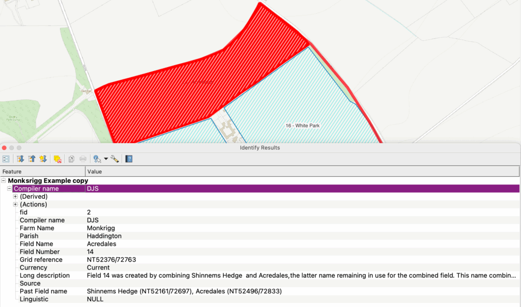
| 2 | 14 | Acredales | Shinnems Hedge (NT52161/72697), Acredales (NT52496/72833) | Monkrigg | Haddington | DJS | In 2025 Monkriggs consists of six large fields, A-F on Plan 1. Names and locations provided by the present farmer. Layout was confirmed from ESRI satellite imagery. Fields A, B & C are the product of field amalgamation since 1973 while fields D (10), E (11) & F (12) have kept their pre-1973 borders. Two of the 1973 fields, 3 and 13, had been sold off by 2025. In tracing the fields histories backwards in time it is simpler to consider the fields 1-13 as shown on Plan 2 of 1973, as this field pattern had been largely unchanged for the previous 200 or so years. Therefore the derivation of the modern names for fields A, B & C is first recorded below then the history of the individual fields 1 -13 is examined in detail. Plan 3 shows the fields in 1760 (drawn onto an extract from 1854 6-inch OS map) A plan of 1801 shows the field layout but does not record their names. Not reproduced. | NT52376/72763 | Field 14 was created by combining Shinnems Hedge and Acredales, the latter name remaining in use for the combined field. This name combines two words. Acre can mean a field or tilled land. Dale meaning in this case a share or portion of land within a common arable field. (From the Dictionary of the Scots language). The 1854 OS map shows the field while the 1801 plan shows two fields in this position. The 1760 plan shows the field as divided into six strips, sizes varying from 4 to15 riggs, being worked by five individuals. These strips/dales/shares or portions of land within the field are the origin of today’s surviving fieldname, Acredales. This field is present on the 1854 6-inch OS map and the 1801 plan. The 1760 plan shows it divided into a series of strips or dales and is named as Skinners Edge (no H). So the (h)edge element of the older name has survived while Skinners has been corrupted verbally or misinterpreted when rewritten with perhaps the ‘k’ being read as an ‘h’ (a Secretary Hand k having a similar form to a modern hand h) and the ‘r’ being read as ‘n/m’. So probably named for a person or occupation. | Field A on plan | Current | ||||||
| 3 | 3 | Cattle Shot | Seggersdean | Haddington | DJS | NT52726/73081 | The field is shown on the 1853 6inch OS map and on the 1801 plan where its crop is recorded as being ‘new grass’. The 1760 plan names the field as Buttle Shot. A Shot is a corner or projecting piece of land (DSL) and this field certainly projects out from the core farmlands. A Buttle is a bundle of hay or straw (DSL). This suggests a past use of this field- as a hay meadow. The later Cattle Shot indicates it was used to hold cattle. | Past | not part of Monkrigg today, so technically should be neighbouring farm? | ||||||||
| 4 | 2 | Acredales | Monkrigg | Haddington | DJS | NT52496/72833 | This name combines two words. Acre can mean a field or tilled land. Dale meaning in this case a share or portion of land within a common arable field. (From the Dictionary of the Scots language). The 1854 OS map shows the field while the 1801 plan shows two fields in this position. The 1760 plan shows the field as divided into six strips, sizes varying from 4 to15 riggs, being worked by five individuals. These strips/dales/shares or portions of land within the field are the origin of today’s surviving fieldname, Acredales. | Past | |||||||||
| 5 | 4 | Middle Park | Monkrigg | Haddington | DJS | NT52253/72509 | Named for its location between two other parks, it is present on the 1854 OS map. The 1801 plan shows the field as divided north-south into two, as was field 7 to the south. The 1760 plan names this area as ‘Ex? ditches’. | Past | |||||||||
| 6 | 5 | Steading Park | Monkrigg | Haddington | DJS | NT52519/72626 | Named for the steading built on the western side of this field in 1853. The field is present on the 1854 6-inch OS map and the 1801 plan, no names given. On the 1760 plan the area covered by fields 5 & 8 is named as Avenue Park and East Avenue Park, with a North-south division between them. Was there once an access way/avenue to Monkrigg House or a previous building from the north? | Past | |||||||||
| 7 | 6 | White Dykes Park | Monkrigg | Haddington | DJS | NT52691/72726 | This field is present on the 1854 OS map and the 1801 plan. In 1760 fields 6 & 9 made up the larger ‘North Field’. White dykes might imply a white field boundary. Dyke implies a hedge or wall today but could also mean a ditch (DSL). | Past | |||||||||
| 8 | 7 | West Lodge Park | Monkrigg | Haddington | DJS | NT52317/72329 | Malcom’s Lodge to the west of Monkrigg House on the 1854 OS map is labelled West Lodge on later OS maps. So the field is named for the building next to it. | Past | |||||||||
| 9 | 8 | Wood Park | Monkrigg | Haddington | DJS | NT52584/72481 | Probably named for its location just north of the tree belt forming part of the grounds of Monkrigg House. | Past | |||||||||
| 10 | 9 | Quarry Park | Monkrigg | Haddington | DJS | NT52834/72547 | This field is shown on the 1801 plan. In 1760 it was part of the larger North Field that included field 6. Although there is no quarry marked on the maps consulted this is likely to be the name’s derivation. Small quarries were often opened up on estates to provide building stone or road ‘metal’. | Past | |||||||||
| 11 | 10 | West Purgatory | Monkrigg | Haddington | DJS | NT52339/72090 | This field’s position today is the same as in 1973, 1854 and 1801. The area had been two fields in 1760, named West Purgatory and Mid Purgatory. Mr Shepherd reports that the two ‘purgatory’ fields are north facing and low yield. In other words, they are hard work for little return, therefore purgatory like. There is no indication of how old this current explanation of the name is. | Current | |||||||||
| 12 | 11 | East Purgatory | Monkrigg | Haddington | DJS | NT52673/72151 | The area covered by East Purgatory today is an amalgamation of four fields recorded on the 1760 plan: East Purgatory, West & East Cowpark and part of the ‘new enclosure’. The more notable name of East Purgatory surviving their combination which had occurred by 1853. | Current | |||||||||
| 13 | 12 | Hobbie’s Hole | Monkrigg | Haddington | DJS | NT52947/72333 | This field retained its essential shape on all the maps and plans back to 1801. Called Hobbies Hole in 1973, the present farmer calls it Habbie’s Hole. In 1760 the field’s area was the eastern part of the ‘new enclosure’. A Hob/hobbie is a mythical creature, a little devil, pixie or such. They were believed to live in holes. The name is applied to hollows or dips in fields. Such features have often been infilled and levelled to allow easier working of the land. | Current | |||||||||
| 14 | 13 | The Loch | Mitchellhall | Haddington | DJS | NT53138/72300 | The Loch was part of the farm in 1973 but by 2025 ownership had been transferred to Mitchellhall, the house immediately north of the field. However The Loch had been part of the farm for the previous 200 years or so, appearing on the 1801 and 1760 plans. In 1760 the field name was recorded as The Loch. Probably the site of a smallish drained loch/pond. | Past | not part of Monkrigg today, so technically should be neighbouring farm? | ||||||||
| 15 | 15 | The Steading | Middle Park, West Lodge Park | Monkrigg | Haddington | DJS | NT52318/72434 | Field B (15) has clearly been named for its proximity to the actual Steading buildings. It combines two fields, Middle Park (4) and West Lodge Park (7), neither name surviving. This new name must have been decided upon at the same time as or after Field C on the plan was created as it incorporated Field 5 which was also called Steading Park. Middle Park (4) was named for its location between two other parks, it is present on the 1854 OS map. The 1801 plan shows the field as divided north-south into two, as was field 7 to the south. The 1760 plan names this area as ‘Ex? ditches’. West Lodge Park – Malcom’s Lodge to the west of Monkrigg House on the 1854 OS map is labelled West Lodge on later OS maps. So the field is named for the building next to it. | Field B on the plan | Current | |||||||
| 16 | 16 | White Park | Steading Park, White Dykes Park, Wood Park, Quarry Park | Monkrigg | Haddington | DJS | NT52665/72628 | Field 16 (C) was formed from four fields: 5,6,8 & 9. Its name is a shortened form of the name of Field 6, White Dykes Park. Named for the steading built on the western side of this field in 1853. The field is present on the 1854 6-inch OS map and the 1801 plan, no names given. On the 1760 plan the area covered by fields 5 & 8 is named as Avenue Park and East Avenue Park, with a North-south division between them. Was there once an access way/avenue to Monkrigg House or a previous building from the north? This field is present on the 1854 OS map and the 1801 plan. In 1760 fields 6 & 9 made up the larger ‘North Field’. White dykes might imply a white field boundary. Dyke implies a hedge or wall today but could also mean a ditch (DSL). Probably named for its location just north of the tree belt forming part of the grounds of Monkrigg House. “This field is shown on the 1801 plan. In 1760 it was part of the larger North Field that included field 6. Although there is no quarry marked on the maps consulted this is likely to be the name’s derivation. Small quarries were often opened up on estates to provide building stone or road ‘metal’.” | Field C on the plan | Current |
Inevitably its a little more complicated to populate the new table and incorporate sensibly old field data. I am not certain its the right approach, but it does illustrate the points well.