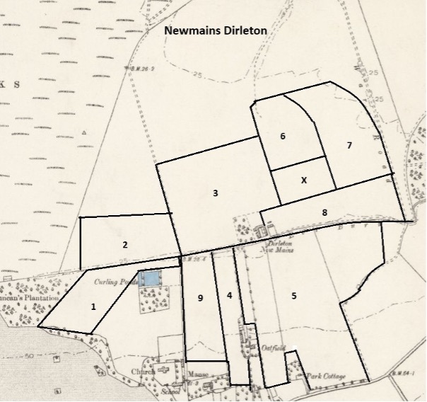
The field names were provided by Mr. R. Simpson who farms Newmains and Castlemains at Dirleton.
On the available OS maps of 1895 and earlier there are no fields recorded north of the Eel Burn (area marked as fields 2,3,6,7 & 8 on map). The land is shown as links. The fields are recorded on the 25inch 1907 OS map, surveyed 1906. Therefore these fields names cannot be older than 1895.
Curling pond has clearly been named for the pond immediately to the east of the field. The pond itself is Victorian. It does not appear on the OS 6inch 1854 map.
Cow Park is probably based on its use, to hold cows.
Byre. Fields are often named for the nearest feature, so in this case a byre at the steading that the field butts against seems likely. This field was created by the amalgamation of two fields at this position, as shown on the 25inch 1907 OS map.
Oatfield is named for the late 18th C. farmhouse located part-way up its east side. It appears on Forests’ 1799 map, with a field shown to the east having a similar shape to No.5 Café.
Café. Mr Simpson reports that there was a village café next to this field and that the name continued in use after the café closed. This field is an amalgamation of four areas, their boundaries can be seen on the map.
Radar was named for the radar station set up in this field in 1943. The station remained operational until 1946 and continued to be used as a training facility until 1954. For further details see ELA&FNS Transactions vol.28. 2008, p117-131. The radar station buildings were converted into a house (at X on the map) in the mid-2000s, with a section of the field becoming its garden.
Road End is another location name, it is at the end of the farm where the Ware Road is.
Horse & Cottage. Mr Simpson reports (i) that an old fence line can be seen across this field so it is probable that two field have been combined. The 25inch 1907 OS map confirms that this area used to be two fields. (ii) That Cottage as a field name probably came from that previous farmers cottage that bordered the field and that Horse may be from the other field being used as a horse paddock. So fields, and possibly their names, were amalgamated.
Glebe is located north of the manse and is the name applied to land provided as part of a Minister’s stipend.

| 1 Curling Pond | Curling pond has clearly been named for the pond immediately to the east of the field. The pond itself is Victorian. It does not appear on the OS 6inch 1854 map. | NT5103984455 |
| 2 Cow Park | Cow Park is probably based on its use, to hold cows. | NT5115484680 |
| 3 Byre | Byre. Fields are often named for the nearest feature, so in this case a byre at the steading that the field butts against seems likely. This field was created by the amalgamation of two fields at this position, as shown on the 25inch 1907 OS map. | NT5143084813 |
| 4 Oatfield | Oatfield is named for the late 18th C. farmhouse located part-way up its east side. It appears on Forests’ 1799 map, with a field shown to the east having a similar shape to No.5 Café. | NT5149384383 |
| 5 Café | Café. Mr Simpson reports that there was a village café next to this field and that the name continued in use after the café closed. This field is an amalgamation of four areas, their boundaries can be seen on the map. | NT5178984467 |
| 6 Radar | Radar was named for the radar station set up in this field in 1943. The station remained operational until 1946 and continued to be used as a training facility until 1954. For further details see ELA&FNS Transactions vol.28. 2008, p117-131. The radar station buildings were converted into a house (at X on the map) in the mid-2000s, with a section of the field becoming its garden. | NT5164984952 |
| 7 Road End | Road End is another location name, it is at the end of the farm where the Ware Road is. | NT5188684994 |
| 8 Horse and Cottage | Horse & Cottage. Mr Simpson reports (i) that an old fence line can be seen across this field so it is probable that two field have been combined. The 25inch 1907 OS map confirms that this area used to be two fields. (ii) That Cottage as a field name probably came from that previous farmers cottage that bordered the field and that Horse may be from the other field being used as a horse paddock. So fields, and possibly their names, were amalgamated. | NT5180984752 |
| 9 Glebe | Glebe is located north of the manse and is the name applied to land provided as part of a Minister’s stipend. | NT5138684422 |
| X Lysander House | ||