Preliminary explorations
In 2025 Joy Dodd and others interviewed a selection of farmers. These are the raw notes and old OS maps (out of copyright) they created. The grid references were plotted onto modern digital maps in QGIS and exported to felt.
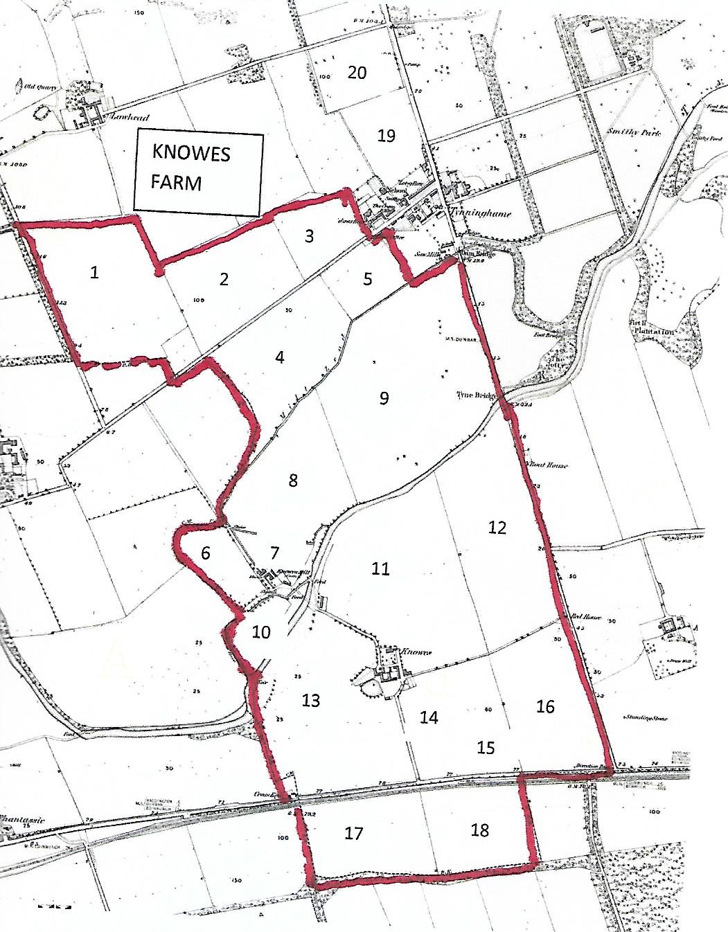
| Number | Name | Grid ref: | Information |
| 1 | Smeaton field | NT60138 78639 | Added in exchange for 17/18 when A1 built |
| 2 | West Tynninghame bank ` | NT60465 78852 | Quarry Park in 1848. 2 & 3 now combined |
| 3 | East Tynninghame bank | NT60792 78995 | Clover Park in 1848. 2 & 3 now combined. |
| 4 | Dowline | NT60622 78638 | 4 & 5 now combined |
| 5 | Cuddy Stank | NT60951 78925 | 4 & 5 now combined |
| 6 | Bog Field | NT 60460 78036 | |
| 7 | Glass House | NT60655 78053 | |
| 8 | Knowes Mill Park | NT60708 78238 | Was added to Knowes farm in 1854 |
| 9 | Acres | NT61054 78656 | |
| 10 | Haugh | NT60617 77838 | |
| 11 | Bastille Braes | NT61013 78019 | Connected with prisoners of battle of Waterloo |
| 12 | Boat House | NT61317 78101 | Duncanhill in 1848 |
| 13 | Stackyard | NT60796 77604 | South part formerly known as Cross Keys Park or westergaitside where there was an Inn in 17th century |
| 13a | Paddock | ||
| 14 | Grieves Paddock | NT61120 7756 | Formerly part of Span Park |
| 15 | Span Park | NT6124877611 | |
| 16 | Hoggs Hill | NT60460 78036 | Iron age-norman settlement excavated 2003 |
| 17 | West Railway Bank | NT60970 77215 | Exchanged for 1 when A1 built |
| 18 | East Railway Bank | NT61406 77272 | Exchanged for 1 when A1 built |
| 19 | Draper-lands | NT60912 79348 | Added to Lawhead farm in 1854 |
| 20 | Calf Park Brae | NT60810 79503 | Added to Lawhead farm in 1854 |
