In practical terms you could do this in any number of ways – with least complex at the head of this list:
1) as a set of WORD documents following a template, such as the one that you have created – some guidance would be needed and someone would stitch it together. You might want to do this anyway as it is an OK way to collate initial information before committing to a database or passing it on. I would keep images separate though as the quality of an embedded image is often degraded once you extract it.
2) as a spreadsheet, with or without a form alongside such as this. In the latter a form is submitted to a database and there’s no need to worry that someone is submitting at the same time. (The attached borgue database to get an idea of what it could like. With this approach you would still need to store any images somewhere, but not the the spreadsheet.)
3) create a new website (like this one) rather than on the existing, with main categories such as parish (missing from Borgue) and field type, farm name and anything else, such sources of evidence etc. categorised as tags etc. also it is possible to add map co-ordinates to a modern map or, conceivably, you could cut and paste images such as old maps – higher resolution is best. While there are tools to add boundary polygons via a website, it is probably better to add boundary info via a bespoke package.
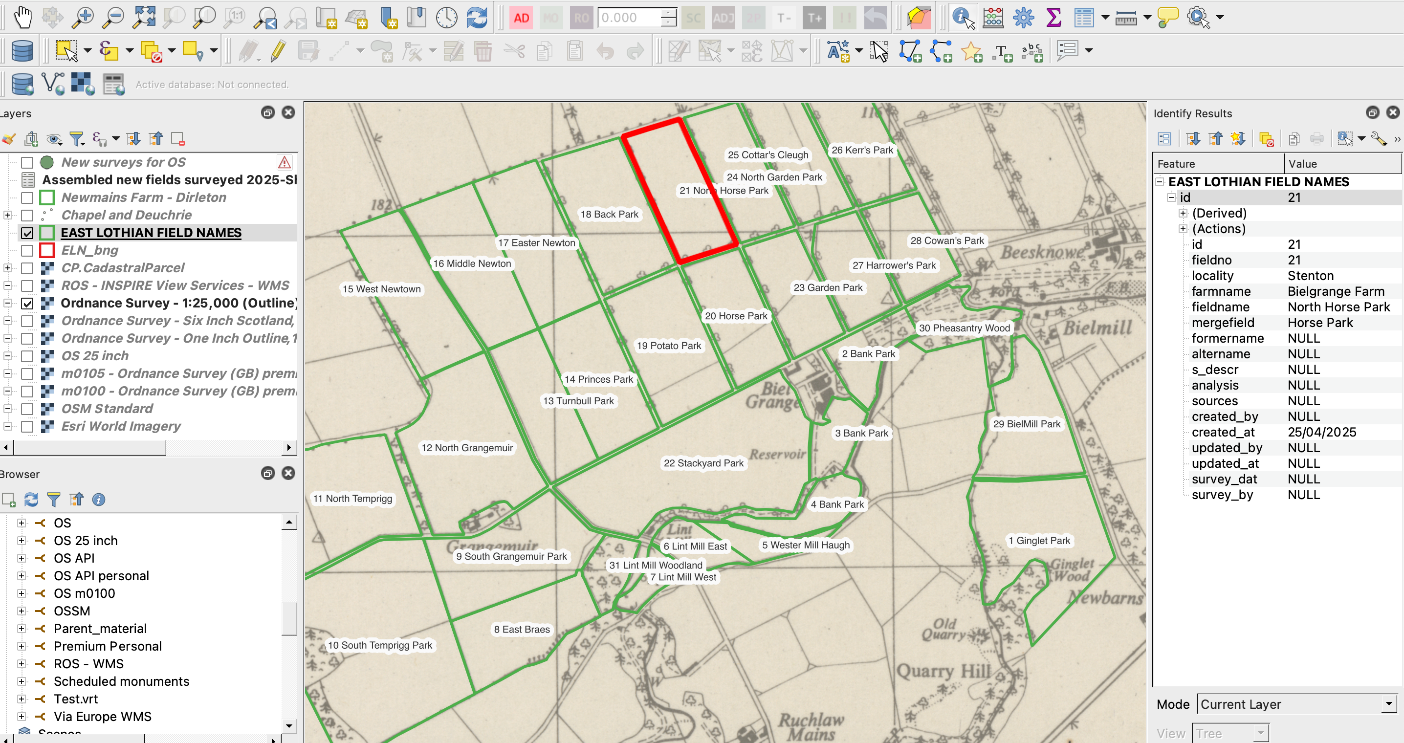
4) Using a bespoke package like QGIS (free software) or ARCGis (we can a charity licence for £140 per year) you can create a simple geographically referenced database of points and basic attributes – the point data set can be categorised and filtered and in theory viewed with your preferred background layers modern or old.
5) As in 4) create a geographically referenced data base of field boundary polygons etc It is more complicated to create and then polygons … but in part that depends on how precise you want the line work to be.
All the above have their advantages and also limitations and lend themselves to different forms of analysis (tables, interrogation, statistics, pretty maps etc) and data extraction for re-usuing elsewhere and publication as the project develops, which might be key to getting fuller public engagement.
- Project Scope & Co
- Defining the exact deliverables, and mapping support needs, fixing the database fields up front will evidently help too.
- If there’s potential for external funding, now is the time to explore the resources needed, but the scope would need to pinned down a bit further.
- Public engagement. It is one way of attracting funding to do citizen science. I am not a fan of website forms and comments though as they attract spam and require a team to be on the alter and moderation in my experience doesn’t happen and users get frustrated and turn comments and web forms off. Fine if you have paid staff who have nothing better to do. But ELAFNS could run workshops, trainings and events, or even field days, which could involve different age groups at different levels (engage young folk in agricultural history and etymology) or simply to recruit new recorders.
- Background and historical Mapping Resources
- The National Library of Scotland do offer an excellent historical map layer resource, which are a great foundation for comparing present and past field boundaries, but maybe the sources need a little guidance and it would be jolly useful to talk this through with NLS to see what practical assistance they could provide – I can approach them, now that you have.
- One can combine a good number of these old maps with the modern open-license maps (e.g. OS open data, OSM, ArcGIS Online) to create interactive layers, but this side is quite technical.
- The best sources are premium, but in many cases if you go under the generous free £1000/month it is OK. I have managed to spend more than I expected on these … so it easy to blow the budget. These online maps are designed to be used on websites and apps, so arguably if we are using these for “development” (not public) we might not pay anything (caveat I’ve not read the small print).
- Also a project run in. conjuction with either NLS or with say ELC could give us access to similar premium resources available under a Government licence.
- Process & Training
- Ideally you want a self-directed system to make it cost manageable, but you’ll still likely need training for viewing sources, data entry, dealing with boundary edits, or, if an advanced system is desired, someone must be willing to learn the basic GIS tasks. I’d say from experience that the digitising side is more challenging and may require close supervision. I have a reasonable amount of experience in visualising and presenting maps and collecting geographical data, but if we can have access to NLS and ELC that would be a good combination.
Let me know how you’d like to proceed with scoping and refining the requirements.
FYI The Borgue database attached and map is quite interesting. It has 2704 entries including quite a few outside of the Borgue area. The matrix is simple enough. There are quite a few gaps, so interesting details are perhaps harder to extract without diving into the text, which can be quite dense and hard to read. For East Lothian, the phase 1 habitat may shows there may well be as many fields as in D&G (a whopping 31,000 parcels, some of these sub compartments).
Anyway that’s probably enough food for thought, and apols if some of this is not really news to you.
Regards
Philip