Here’s a step-by-step summary of the methodology used in the Borgue Field Name Project, structured across the collection, recording, and digital mapping stages:
1. Project Initiation
- Inspiration: Sparked by a 2019 local heritage talk featuring Professor Ted Cowan and Michael Ansell.
- Aim: To collect, analyze, and preserve field names across a defined part of Borgue parish (Fleet to Dee, north to the A75).
2. Field Name Collection
- Outreach: Local farmers were contacted and interviewed.
- Materials used:
- 1:25,000 OS maps.
- 1854 first edition Ordnance Survey maps (photocopies).
- Occasionally, existing farm maps.
- Process:
- Field boundaries were verified or corrected.
- Field names and meanings were noted.
- Oral tradition was essential; many names had never been written down.
- Challenges included capturing accurate pronunciation and dealing with reluctant landowners.
3. Supplementary Sources
- Archival research: Used:
- Adam Gray Sr.’s booklet (1999) with field names and 1908 OS map references.
- Historic maps from estate archives (1780, 1819).
- Farm diaries and private collections.
- Personal testimonies: Retired workers from farms provided missing names (e.g., Calrevan area).
4. Data Recording
- Maps: Field names plotted on a large working basemap.
- Spreadsheet: Names, pronunciation notes, and contextual information were entered.
- Collaboration: Data shared with linguistic analysts (Alan and Michael) for etymological input.
5. Digital Mapping & Outputs
- Mapping: Digital map created by John from spreadsheet data.
- Painted map: Visual companion updated by Anne.
- Website: Built to share data and gather crowdsourced contributions to fill remaining gaps.
6. Key Challenges & Insights
- Data loss: Some farms had completely lost field names.
- Land tenure: Continuity in farm ownership aided memory retention.
- Local variation: Same field names existed across different farms with minor differences.
- Names as history: Revealed crofting past, courtship paths, and agricultural practices.
This is derived from the video, which is transcribed below.
00:00:03 the borg field name project the seeds of the borg field name project were sown at a talk in february 2019 organized by the place in the biosphere project part of the great places scheme run by the national lottery heritage fund the talk about borg by historian professor ted cowan and place name enthusiast michael ansel inspired proposal by people living locally to take a closer look at place names and field names in the area a plan was hatched to gather field names analyze their meanings and share the information with a wider
00:00:41 audience the speakers myself john and michael were key members of the team and in these three short presentations we will explain how the field place name project developed along with some of the outputs if you take a walk through any landscape in scotland there’s a story to be revealed of human lives and the impact we have had on the land around us if you’ve used a map to go for a walk you’ll no doubt have come across intriguing or unusual place names but did you know that nearly all fields have a name
00:01:20 and that these names might tell you about the history of the field and its use over the centuries old field names act as clues to the past telling the story of a place and can connect you with the history of the area put yourself in the shoes of the farmer who originally named them the names originated in a very practical way to identify them for farm labourers it was clearly important that they did not go out and plough the wrong field many of these names were never written down so that the names used today
00:01:54 are the result of a largely oral tradition where the original name may have evolved or changed over many years and can sometimes be hard to decipher i’ve had a lifelong fascination with maps and michael and ted’s talk in the pub was a light bulb moment and i grabbed the chance with both hands how brilliant would it be to be able to say i saw a hair in the drum field today instead of i saw a hair in the field that’s next but one to the one on the right hand side of the road going up the lane or to be able to tell a farmer that’s a
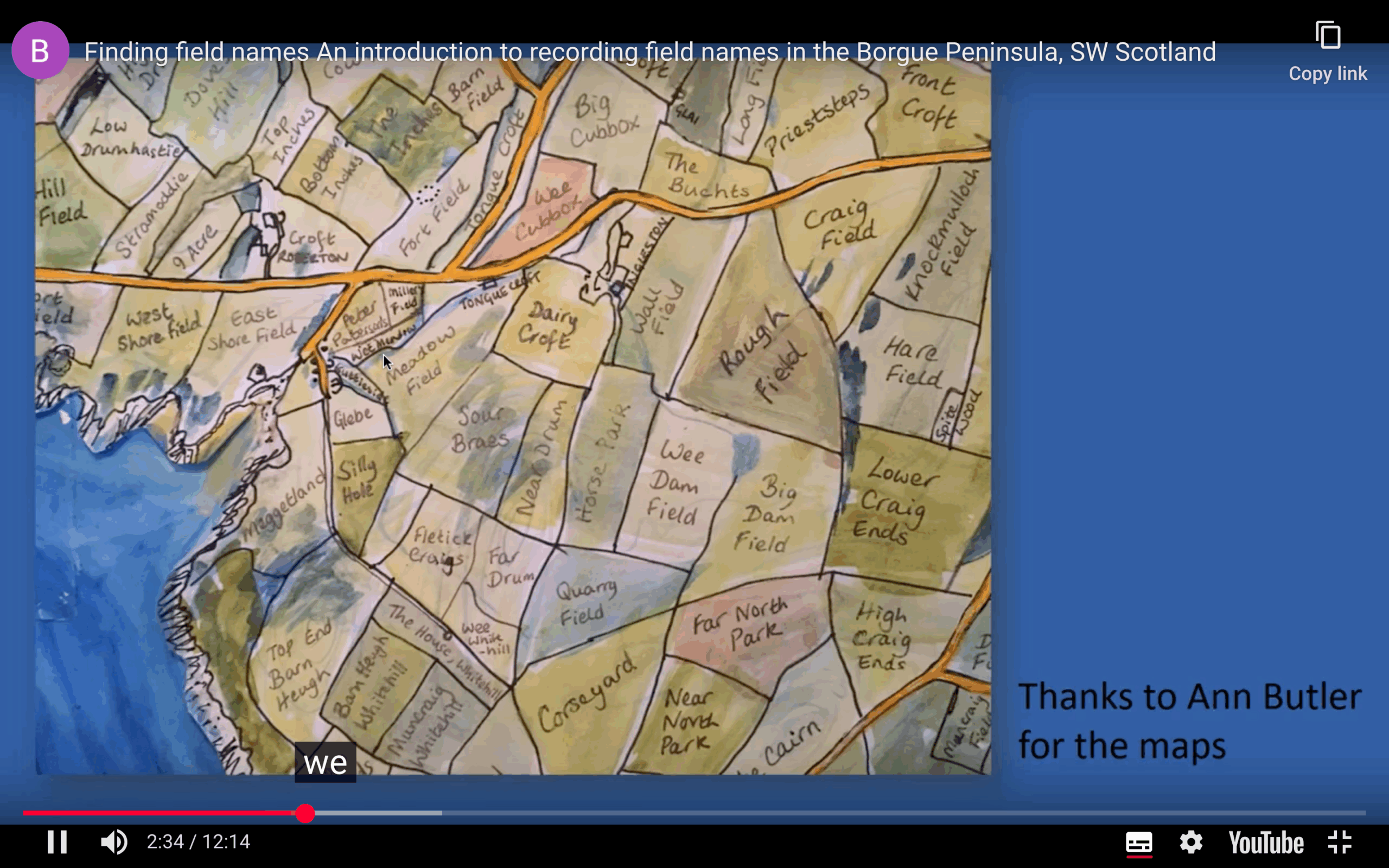
00:02:30 sheep in trouble in the horse park we decided to limit the scope of the project to an area from the fleet in the west to the d in the east and north to the a75 i started to contact local farmers and armed to the one to 25 000 os map and large photocopies of the 1854 first edition maps for the area i set out if i was lucky there was a farm map to work from but usually it was a case of referring to the os map i made notes on the names and any other information that came to light on why a field had a particular name
00:03:11 and i also made sure that the field boundaries shown were correct as many field boundaries have changed over time one problem that i did encounter was that not being local it was sometimes difficult for me to record the pronunciation of the name a neat version of the maps and notes were sell and sent to alan and michael and just like magic their analysis on the field names came back i transferred the field names to a large working base map and all the other information collated onto a working spreadsheet
00:03:45 john started uploading the information onto the digital map and anne updated her painted map luckily in many cases the farms had been in the same family for several generations all the families had only moved from one farm to another within the area this resulted in a wealth of other information and recommendations on who to go and see next but in a few cases the farms had changed ownership many times and were now being run by incomers possibly the biggest challenge was the area around cal raven
00:04:19 brickhouse and high nunton where the old names had been discarded however i was lucky that an article in the galloway news asking for help was read by a lovely gentleman living in castle douglas who used to work on coal raven in the 1960s he could remember the names as if he had just stepped in from the fields that morning and not only that but he also put me in touch with some of his friends who also used to work on other farms in the area this was a real breakthrough however sometimes we did struggle with
00:04:52 actually putting names onto the correct fields on the map so in a few cases we ended up with a variety of names for some of the fields which we had to untangle i was overwhelmed with how supportive the local community was and how keen everyone was to share and to find out more about the names of the fields i’ve been very fortunate to have met some really lovely people to have been welcomed into their houses and to have heard wonderful stories about their farms and the area it’s been a real privilege and i would
00:05:24 like to thank everyone who has helped i continued to make good progress but finding the names gradually became much harder and in fact it was really disheartening to be told by a couple of farmers that my field names are my business and even more so when i was told data is the new oil how much are my field names worth so i realized that if i was going to make more progress in filling in the blanks i would have to look for alternative information sources david deveraux came to my rescue when he told me about adam gray senior’s booklet
00:06:02 in the museum adam’s booklet dating from 1999 did indeed contain field names for many of the farms in the parish but unfortunately no maps however next to some of the names was a number and i realized that this was the field number from the 1908 os map so i was able to use that data to fill in some blanks adam’s name covered the list of the old parish of borg extending further north on the a75 so as i had the information to hand i decided to follow in his footsteps and this took me as far north as greenslack
00:06:39 adding in quite a few more fields along the way whilst alan and michael were wrestling with a linguistic origin to the names and you can hear more about this from michael i enjoyed the slightly more quirky discoveries that we made along the way on the map on the left you can see that two farms both have a field next to the weasel wood which does indeed still have weasels in it one is called the weasel field and one is called the weasel wood field very often where two farms meet the fields are named after the adjoining
00:07:18 farm the map on the right shows the boundary between borland farm and carrick farm ball and march is a field on carrick farm and is the field closest to ball and farmland whereas big carrick is a field on borland farm which is closest to carrick farmland at ratra we puzzled over the field name piper walls and it was only when we looked at the 1854 map that the reason for the field name became apparent an old croft long disappeared and one of my absolute favorite stories is that the lane running running alongside this farm
00:08:02 together with one of the fields was called cuddle cosy apparently this was a favorite route for courting couples from the village at ingleston we puzzled over who peter patterson was it turned out that in 1945 he was a dairy man at course yard working for james brown and presumably lived in a cottage next to the field i especially loved the moments during conversations when i was asked oh would you be interested in seeing this and a treasure would appear from a cupboard or the cellar such as this wonderful set
00:08:43 of diaries from the mains of twinum farm dating back to 1896 which contained so much detail on day-to-day farming life and on the right you can see an extract from a huge map from the hardware estate which showed how land was often swapped rather than sold it says mill of plunton was ex-cammed to mrs elizabeth murray usher of cali in 1931. at bolton.org i was lucky enough to be shown two very old estate maps one from 1780 on the left and the other from 1819 both beautifully colored which both contained
00:09:29 a wealth of detail fabulous field names such as scroggy yeard and they also showed me that the old high road used to skirt around the other side of the mot this is the road in 1780 and this is where it is in today’s time you can see how the shape of the two large fields here in 1780 are exactly the same today this map of mikkel ross by john gallon from the 1700s was first shown to us by archie from the damp project and was a treasure trove of information as well as john paul jones’s ship it also showed that the position of the
00:10:18 roads had changed and that the original ross farm was on the western side of the point in foldbog bay i overlaid the old names onto the modern map to show again that whilst most of the fiend boundaries are the same it is only the name that has changed over time the most recent treasure to come to light was this map from borg house or lay borg as it was known in 1780 again the roads have changed but many other fields were exactly the same shape and name sadly at one farm we were too late here the names of the fields were lost
00:11:03 many many years ago and even in 1999 adam gray recorded them as first second and third fields the farmer was as disappointed as i was but delighted to find that i could tell him that some of his fields did have older names which he was keen to bring back into use before i finish i would like once again to thank everyone who has helped in any way over the past two years but we’re not quite finished we have still got some fields which are unnamed at clock and dolly glen terry and a few fields in the central area
00:11:41 around elston and gled park if you think you could shed some light on these field names i would be very grateful if you could take a look at the website which john will be talking about and see if you can fill in any of the gaps because if we don’t manage to find their names then this is the only way that these fields will be referred to and finally i would love to encourage you to undertake the same project in your own area before it’s too late thank you