Preliminary explorations
In 1998 David Sydeserf interviewed a selection of farmers and published the field names on old edition OS maps in the ELAFNS Transactions. We attempted to use OCR to read the text and annotated map, with mixed results.
Interview with Mr Elder, farmer, Chapel, Dirleton. 4 July 1992.
Mr Elder took over the farm in 1954 from his uncle who had been there since 1949. This uncle built the current farm house
c. 1949-50; previously, it had been a ruin. Most of the farm consists of old-style buildings and there are plaques marking 18th century historic buildings. One of . these buildings Mr Elder suggested was the original farm house, similar in shape and construction to Sydserf house, with an outside stair-case to the· first floor; it was apparently used as a POW “bothy” during World War Two, there being names graffitied on to the walls (in German). Also, there are two wells on the farm, both now dried up. On the western side of the farm there used to be workmen’s bothies, now removed; hence the name of the field here, “Bothy Field” (No. 12).
Mr Elder has a map of the farm and its lands, dating from 1855 when it was part of the estate of the Marquis of Dalhoussie; this map names the various fields (which names given below), and also notes the railway. The farm today covers the same lands as it had then.
Mr Elder has never heard of the names Arnotflatt or Chapelside. The name of Skateraw field (property of Highfield) was not familiar to him; there is a dyke separating the fields of Chapel and Highfield here.
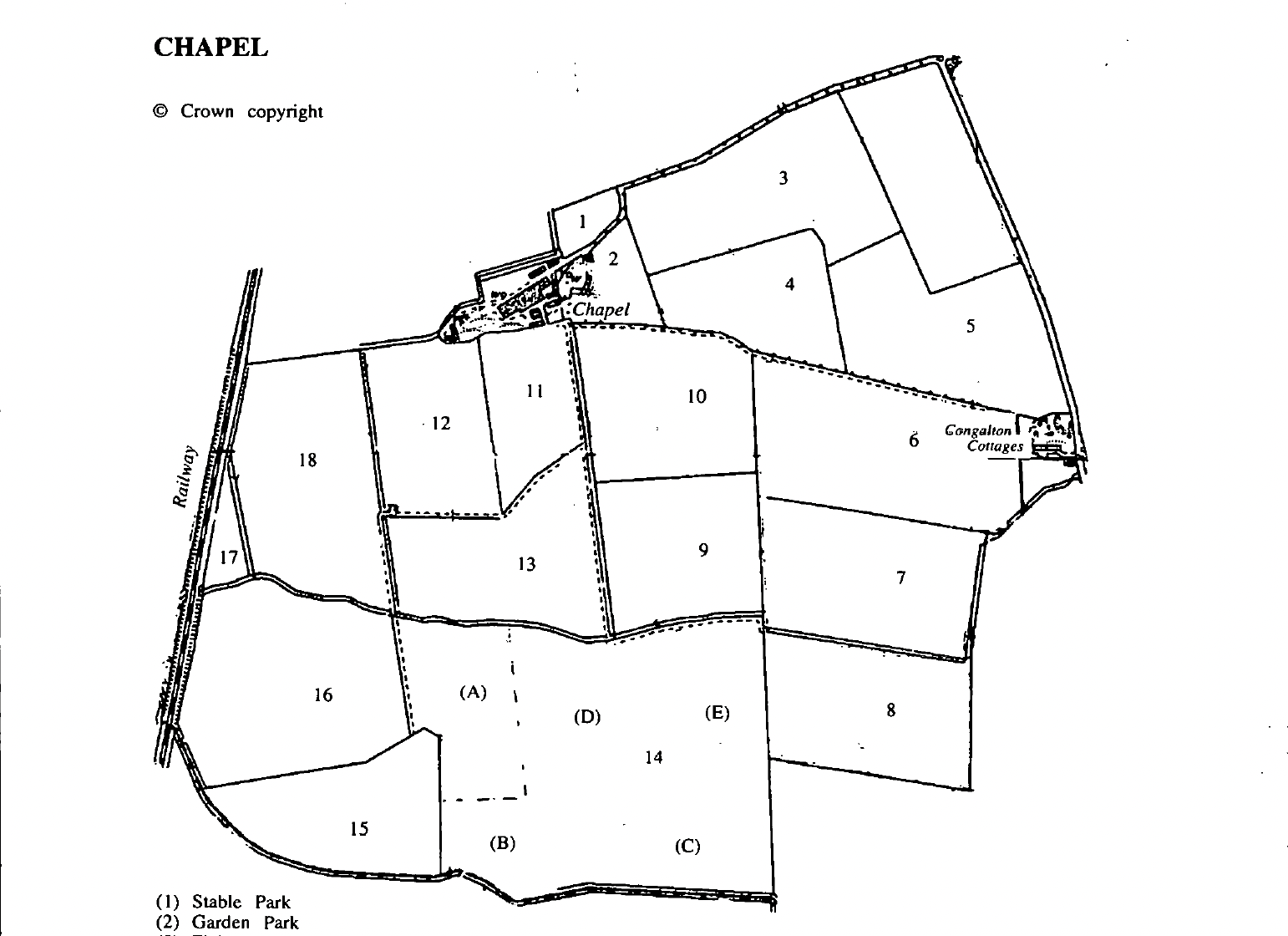
A number of fields on Chapel now have no particular name, viz “Field Up The Road” (No. 3), “Field(s) Below the House” (Nos. 10 & 11), “Pylon Field” (No. 6).
Finally, it was noted that Mr (and Mrs) Elder pronounce the name Sydeserff as “side-serf’.
(Note: the first name given in the following is the one used today, the former names – marked “f’ – applies to the names on the 1855 map mentioned above: if no. former name is given then the name is the same today as it was then.)
| field_no | locality | farm_name | field_name | merged_fields | former_name | alt_name |
| 1 | Dirleton | Chapel Farm | Stable Park | – | – | – |
| 2 | Dirleton | Chapel Farm | Garden Park | – | – | – |
| 3 | Dirleton | Chapel Farm | Field up the Road | – | f. in two parts, ‘Hole Park’ on the west, and ‘Broomielands’ on the east | – |
| 4 | Dirleton | Chapel Farm | The Bank | – | f. ‘West Bank’ | – |
| 5 | Dirleton | Chapel Farm | Quarry | – | f. ‘East Bank’ | – |
| 6 | Dirleton | Chapel Farm | Pylon Field | – | f. ‘South Bank’ | – |
| 7 | Dirleton | Chapel Farm | East Mill Burn | – | f. ‘Mid Bank’ | – |
| 8 | Dirleton | Chapel Farm | Congleton Field | – | – | – |
| 9 | Dirleton | Chapel Farm | Mid Mill Bum | – | – | – |
| 10 | Dirleton | Chapel Farm | Field Below the House | – | f. ‘Captain”s Park’ | – |
| 11 | Dirleton | Chapel Farm | Field Below the House | – | f. ‘Stackyard Park’ | – |
| 12 | Dirleton | Chapel Farm | Bothy Field | – | f. ‘Law’ | – |
| 13 | Dirleton | Chapel Farm | West Mill Bum | – | f. in two parts, ‘Wood End’ on the west, and ‘Gaw”s Field’ on the east | – |
| 14 | Dirleton | Chapel Farm | 90 Acres | – | f. as follows (a) belt of fir trees – now gone; no name; (b) Plantation Field; (c) Peffer”s Park; (d) Fir Park; (e) Dobbie Park | – |
| 15 | Dirleton | Chapel Farm | Prora Field | – | f. ‘South Muir’ | – |
| 16 | Dirleton | Chapel Farm | 36 Acres | – | f. in two parts, ‘North Muir’ and ‘Mid Muir’ | – |
| 17 | Dirleton | Chapel Farm | Rosie Comer | – | – | – |
| 18 | Dirleton | Chapel Farm | Railway Field | – | – | – |